 |
| GOES-12 Visible imagery of Katrina |
 |
| GOES-12 Infrared (IR4) imagery of Katrina |
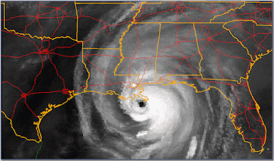 |
| GOES-12 Water Vapor (IR3) imagery of Katrina |
After peaking in intensity on the 29th, Katrina rapidly deteriorated as it approached the Gulf Coast. Such a drastic change was likely due to an incomplete eyewall replacement cycle, leaving the hurricane with a compromised inner core. Despite the rapid weakening, the storm was still a strong category 3 hurricane with maximum sustained winds (MSW) of 110 kt when it made landfall on the Mississippi delta near the town of Buras, Louisiana at 6:10 am CDT. Because the radius of maximum winds was very large, it is likely that the tip of the delta experienced category 4 winds while the storm center was still well offshore. However, this will never be known for certain since most anemometers (the instrument that measures wind speed) break well before winds reach category 4 strength and Doppler radar is only configured to be able to read up to 64 kt, far short of the 114 kt threshold for category 4 storms.
Finally, at 9:45 am CDT, Katrina made its third and last landfall near the mouth of the Pearl River at the Louisiana/Mississippi border, still as a category 3 hurricane. However, these winds were likely limited to portions of the storm still over water and just east of the eye. Thus, the city of New Orleans did not experience category 3 winds, and likely only experienced category 2 winds briefly. This analysis is complicated by the fact that New Orleans is a fair sized city with high rise buildings downtown. It turns out that the strongest winds in a tropical cyclone are found several hundred meters above the surface, thus the tops of very high buildings will experience a noticeably higher wind speed than their bases. As a rough example, the 25th floor of a high rise will likely be impacted by winds one category higher than at the surface.
 |
| Katrina is captured in this true color image from the MODIS unit on the Aqua satellite at 2:10 pm CDT (1910 UTC), shortly before it degraded into a tropical storm. At each line, the MSW in knots are on the left and the central pressure in millibars is on the right. The thick segment of the track line shows the approximate storm's track for 8/29/05. |
After landfall, Katrina began accelerating northward and began turning east while weakening rapidly. Despite this, its' tropical storm force wind radius remained large, even as its' hurricane force radius shrunk significantly. By 1:00 pm, New Orleans was still experiencing storm force winds, thus the city was subjected to at least tropical storm force winds for over 18 hours. The storm also produced heavy precipitation along and just west of its path, including a measured 11.63" at the Slidell NWS office. As it continued inland, it weakened to a tropical storm at 7:00 pm CDT, yet still produced precipitation totals of 4" to 8" over inland Mississippi.
 |
| Using the same image as above, rings have been placed around the center at the average radius of hurricane force winds (red), storm force winds (green), and tropical storm force winds (blue). It is important to remember that these radii are averages; the actual radii had some significant asymmetries. |
 |
| This loop of base reflectivity (left) and base radial velocity (right) radar data from the Slidell radar (KLIX) at the beginning then switching to the Key West radar (KBYX). The whole loop spans from 12:00 am CDT to around 7:00 pm. At the top of each pane is color scale and at the bottom right is the time in CDT. Notice that the radial wind speed color scale ranges +/- 80 kt instead of the +/- 60 kt range used in the first radar post. It is important to note the the radar is only capable of measuring velocities between -64 kt and +64 kt, thus the velocity data can only show the extent of the hurricane force (64 kt) winds, even though the maximum winds might be significantly greater. (Click on the image to view the loop at full size) |
What did the most damage in the New Orleans area was floodwater. This occurred as a result of Lake Pontchartrain overflowing its banks and levees breaking. In this respect, the extraordinary damage New Orleans suffered was due to both a natural and a man-made disaster. The official Tropical Cyclone Report for Hurricane Katrina summarized the flooding damage:
"Although the storm surge was highest to the east of the path of the eye of Katrina, a very significant storm surge also occurred west of the path of the eye. As the level of Lake Pontchartrain rose, several feet of water were pushed into communities along its northeastern shore in St. Tammany Parish from Slidell to Mandeville, Louisiana. High water mark data indicate the storm surge was 12 to 16 ft in those areas. The data also indicate a storm surge of 15 to 19 ft occurred in eastern New Orleans, St. Bernard Parish, and Plaquemines Parish, while the surge was 10 to 14 ft in western New Orleans along the southern shores of Lake Pontchartrain. Farther west, observations indicate a storm surge of 5 to 10 ft along the shores of western Lake Pontchartrain. The surge severely strained the levee system in the New Orleans area. Several of the levees and floodwalls were overtopped and/or breached at different times on the day of landfall. Most of the floodwall and levee breaches were due to erosion on the back side caused by overtopping, but a few breaches occurred before the waters reached the tops of the floodwalls. The surge overtopped large sections of the levees east of New Orleans, in Orleans Parish and St. Bernard Parish, and it also pushed water up the Intracoastal Waterway and into the Industrial Canal. The water rise in Lake Pontchartrain strained the floodwalls along the canals adjacent to its southern shore, including the 17th Street Canal and the London Avenue Canal. Breaches along the Industrial Canal east of downtown New Orleans, the London Avenue Canal north of downtown, and the 17th Street Canal northwest of downtown appear to have occurred during the early morning on 29 August. Overall, about 80% of the city of New Orleans flooded, to varying depths up to about 20 ft, within a day or so after landfall of the eye."

 |
| New Orleans before (top) and after (bottom) Katrina. Notice how most streets flooded and a major levee breach can be seen in the far right side of the image. |
Elsewhere, storm surge was by far the greatest threat. Along a 20 mi swath of coastline, centered on St. Louis Bay, storm surge was 24 to 28 feet. Storm surge values remained in the 17 to 22 ft range as far east as Pascagoula, MS. In many places, the surge extended as much as 6 mi inland and up to 12 mi along bays and rivers. Even further east, Dauphin Island, off the coast of Alabama, was effectively cut in two when the storm surge carved a new inlet a mile wide. Furthermore, 64 mi south of Dauphin Island, a NOAA bouy reported a peak significant wave height (defined as the average of the one-third highest waves) of 55 ft at around 6:00 am CDT.
 |
| The Gulf Coast between Pass Christian and Long Beach where the highest storm surge hit before (top) and after (bottom) Katrina. The bright line that developed running roughly parallel to the coast appears to be a wall of debris carried inland. |
 |
| Along the coast of Biloxi, MS casinos are built on barges to bypass gambling laws. After Katrina (bottom) several had broken free and ended up onshore (three examples can be seen in this image). It looks like gambling won't be taking place in these buildings anymore. |
 |
| Dauphin Island before (top) and after (bottom) Katrina. The inlet that developed was over a mile wide. |


No comments:
Post a Comment