 |
| GOES-12 Visible imagery of Katrina |
 |
| GOES-12 Infrared (IR4) imagery of Katrina |
 |
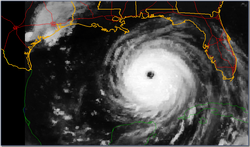
| GOES-12 Water Vapor (IR3) imagery of Katrina |
Immediately following its dramatic expansion in size on the 27th, Katrina entered a period of incredible rapid intensification. Between 7:00 pm CDT on the 27th and 7:00 am CDT on the 28th, the storm intensified from a low category three hurricane to a strong category five monster. At around 1:00 pm CDT, Katrina reached its peak intensity with 150 kt maximum sustained winds (MSW) and a central pressure of 902 mb. At the time, this was the fourth lowest pressure ever recorded in the Atlantic. Oddly enough, by the end of October, Katrina's minimum pressure had dropped to sixth place.
 |
| Katrina is captured in this true color image from the MODIS unit on the Terra satellite at 12:00 pm CDT (1700 UTC), just before its peak intensity. At each cross, the MSW in knots are on the top and the central pressure in millibars is on the bottom. The thick segment of the track line shows the approximate storm's track for 8/28/05. |
By the time Katrina had reached peak intensity, tropical storm force winds were already about to impact the Gulf Coast. However, soon the storm began to rapidly decay. This was likely due in large part to the formation of new ring of convection and the subsequent deterioration of the eyewall that had been built up on the 27th. . By this point, however, Katrina had nearly tracked around the ridge over Florida and it became very clear that New Orleans was to be its target.
 |
| Using the same image as above, rings have been placed around the center at the average radius of hurricane force winds (red), storm force winds (green), and tropical storm force winds (blue). It is important to remember that these radii are averages; the actual radii had some asymmetries. |
The following photographs were taken from a NOAA P-3 Orion hurricane research aircraft flying inside Katrina's eye around the time of its peak intensity.
 |
| Looking straight as the inner edge of the eyewall, with shallow convective clouds obscuring the ground. |
 |
| Part of the eyewall to the left is casting a shadow into the eye. |
 |
| Stiations in the clouds on the inner side of the eyewall can be seen twisting upward in a cyclonic (counter-clockwise) direction. |
 |
| It appears some cirrus overcast is obscuring the far left side of the eye. |
 |
| Looking down onto the shallow bands of clouds that lie at the base of the eye. |
 |
| Notice how the bands twist into the cyclonic pattern as soon as they reach the eyewall. |
 |
| The "stadium" shape of the eye is quite obvious here. |
 |
| This photo captures many of the features shown above in the same image. |
can i use some images for a school project that i will receive no money for i will give credit.
ReplyDelete