In 101: Clouds, I covered the basics of what clouds are and
how they form. In 101: Clouds II I went into detail about the low etage of
clouds. After that, in Clouds III I finished up the official cloud types with
the middle and high etages. In this final Clouds post I highlight a few
“clouds” that are not one of the official ten genera, or at least not in their
typical forms. I’ve ordered these based on their typical altitude; so I’ll
begin with fog.
Fog is essentially stratus that has formed in contact with,
or very close to, the ground. There are two primary types of fog, based on how
they form. Radiation fog is likely the most common form. Layers of these occur
when air very near the surface is cooled due to heat loss. Often this happens
on cold, otherwise clear, nights when the ground radiates heat off into space,
hence the name “radiation”. As the ground cools, the air that is in contact
with it will lose its heat to the cold ground, causing the air itself to cool.
If the air cools to its dew point, water vapor will begin to condense into
cloud droplets; it is these droplets that become the fog layer. The other
common fog type is advection fog. This variety occurs when moist, but not yet
saturated, air moves (or “advects”) over top of a cooler surface, allowing the
air to cool to its dew point. Advection fog is very common in coastal areas
where air from over the land moves out over the cooler ocean. It should be
pointed out that fog experienced on elevated terrain might not actually be fog
if it is not present at lower elevations; in this case, the “fog” is more than
likely just a stratus layer that has intersected the hill or mountain.
When a large wildfire occurs, one or more convective clouds
might form. The reason for this is that the air above a large fire is the ideal
cloud forming environment. The fire itself provides an abundant heat source to
fuel the convection and the smoke particles are great surfaces for cloud droplets
to form. Under particularly good conditions, pyrocumulus may evolve into
pyrocumulonimbus.
 |
| A long chain of lenticular clouds |
 |
| A thin lenticular cloud over some vigorous convection |
 |
| A "UFO" near Roswell, New Mexico |
 |
| Lenticular cloud |
 |
| Lenticular clouds appearing well downwind of the mountains that caused them |
 |
| MODIS image of a lenticular cap cloud over Mt. Fuji |
These oddly shaped clouds are technically a species of
altocumulus, called Altocumulus lenticularis. This lens shaped cloud often
forms as a result of a terrain feature, such as a mountain. If a layer of
nearly saturated air, with dry air above it, is forced to ascend over a
mountain, the air may cool enough to form a cloud. This cloud will appear to
remain stationary, despite the fact that the air forming the cloud is
constantly moving. If there are several alternating layers of moist and dry
air, several of these clouds may form on top of each other like a pile of
plates. The strange appearance of lenticular clouds is responsible for many of
the most famous UFO sightings. Sometimes the air mass will oscillate up and
down after clearing the mountain, which may form a series of clouds extending
downwind, away from the mountains. These clouds also may appear directly above
a vigorous cumuliform cloud; however these are usually very short lived.
 |
| These nacreous clouds appeared above a research station near the Antarctic coast on June 3, 2009 |
 |
| These are the same clouds as seen by the Terra/MODIS at about the same time |
 |
| Same as the image above but with a different wavelength |
 |
| I used the same data as in the above two images, but re-projected it to improve clarity. In this image's coloring, the PSCs appear as dark grey zones, which are circled in yellow. |
 |
| This data is from a Lidar instrument that is essentially seeing the height of the clouds. The one bright mark near the top of the image is the PSCs seen in the images above; all the other marks are tropospheric clouds, which are less than half as high. |
These clouds, also referred to as polar stratospheric clouds
(PSC), occur high in the stratosphere at 15,000 to 25,000 meters, this is about
twice as high as the some cirrus clouds. Since the stratosphere is so much
drier than the troposphere, PSC are generally only observed near the poles in
the winter where the air is coldest. These clouds are usually seen around
sunset when the sun’s rays are still illuminating them, even though the sun has
dropped below the observer’s horizon. PSC are often brilliantly colored, which
is where their nickname, mother-of-pearl clouds, comes from. One interesting
note about these clouds is that they are usually composed of drops of nitric acid
and/or sulfuric acid, along with the typical water drops.
Noctilucent clouds, meaning "night-shinning", are the highest clouds ever
observed, located in the mesosphere at 76,000 to 85,000 meters, which is about six
times higher than most cirrus. These clouds, sometimes called polar mesospheric
clouds, are incredibly faint so they can only be seen late at night. Usually
seen near the poles during summer where the sun can drop below the horizon,
while still illuminating these high elevations; noctilucent clouds typically appear as thin,
light blue strands. The exact nature of these clouds, and how they form, is
still a very active area of research, especially since the mesosphere is about
one hundred million times drier than the Saharan Desert. The problem with
studying these clouds is that they inhabit a zone that is above the altitude
that weather balloons reach, but below the orbit of satellites. This is the
same altitude where meteors begin to burn up and some types of aurorae occur.
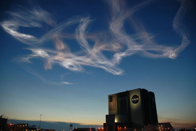
Manmade noctulecent clouds are often formed from the exhaust plume of rockets.


No comments:
Post a Comment