The Science of Weather Radar
The Beam
A radar beam is nothing more that a pulse of light. Since light can be thought of as a basic sine wave, it can be described by its wavelength or frequency; for the purposes of weather radar, typically wavelength is used. All types of radar use light in the microwave portion of the spectrum (figure 1), which has far longer wavelength than the visible light we can see. Visible light ranges roughly between 0.00004 and 0.00007 cm, while radar uses microwave light with wavelengths between about 1 and 10 cm. Because of the many uses of microwaves, engineers often describe particular microwave wavelengths as named bands. The US' WSR-88D, and the retired WSR-57, uses the S-band (the S stands for short), which has a wavelength of about 10 cm. The TDWR and WSR-74C on the other hand use the C-band (C is for compromise between the longer S and shorter X bands) with a wavelength of 5 cm. Finally, the original WWII radars, as well as current airborne units, use the X-band (X comes from it beginning as a 'secret' band in WWII), which has a wavelength of 3 cm. The important thing to remember is that shorter wavelengths provide higher resolution, but the beam is more easily degraded, thus they have shorter ranges.
 |
| Figure 1: These are the various bands along the microwave spectrum, along with visible light for reference. The bands used by weather radar (S, C, and X) are near the center of the graph. |
The basics of how a radar works is actually quite simple. When the radar beam encounters a particle, the light ends up being scattered in all directions, the portion of the scattered light that returns to the radar is called backscatter; this is what provides the radar with information. This type of scattering behavior is called Rayleigh scattering and applies to all particles with a diameter less than about one-fifth the wavelength of the beam, thus for S-band radar the cutoff is 2 cm and for C-band it is 1 cm. Therefore, large particles, particularly hail, scatter light in a much more complicated manner called Mie scattering (which will not be covered here due to its complexity). The amount of energy that returns to the radar is incredibly small relative to the amount emitted by the radar unit. The WSR-88D transmits at about 106 watts while the amount that returns to the unit may be on the order of 10-12 watts. Thus radar power is typically expressed as decibels, which is a logarithmic scale.
The Radar Volume
One advantage the NEXRAD system has over previous networks is the ability to produce volume scans. One volume scan contains all the data gathered from all tilts of a full 360 degree sweep (figure 2). The tilts available to the WSR-88D range from 0.5 degrees (a few units also include a 0.1 degree tilt) to 19.5 degrees. Anything that exists above the 19.5 degree angle will not be seen by the radar, thus this region above the radar volume is known as the "cone of silence". When displayed, the radar volume can be broken up into individual pixels, known as gates. Each gate's dimensions are measured by the width of the radar beam (in both the horizontal and vertical), known as the radial resolution, and the width along the beam's radial, known as the gate resolution. It is imperative to remember that even though the radar might be set to a specific tilt, the beam itself has width, which increases with distance from the radar. Thus while the radial width of each gate remains constant, the horizontal and vertical dimensions become larger with distance (a rule of thumb is that a 1 degree wide beam will have a diameter of 1 mile for every 60 nautical miles from the radar unit). Originally, the WSR-88D's gates were 1 degree by 1 km. However, in 2008, using some fancy computer coding work, the entire NEXRAD network was upgraded to "super resolution", which increased the radial resolution to 0.5 degrees and the gate resolution to 0.25 km.
 |
| Figure 2: This is a cross-section straight through the radar volume showing all 14 tilts in super resolution. The radar unit itself is located to the left of the center where the various radials converge, while a developing thunderstorm is near the center. |
Contained in each volume scan package are three levels of data (figure 3). Level I data is relatively meaningless to humans and is only available at the radar unit itself to engineers. Level II data is the raw data types at their maximum resolution: reflectivity, radial velocity, and spectrum width. Since the upgrade to dual-pol, differential reflectivity, correlation coefficient, and specific differential phase have been added to the level II data stream. Finally, there are the level III products, which consist of derived values computed by the radar. Each level III file is two dimensional, consisting of just one tilt (where applicable), one product, and are identified by a three letter code. The lower tilts of the level II products are made available as level III flat files that have typically undergone some quality improvements. Common examples of the computed data are composite reflectivity, storm-relative radial velocity, precipitation totals, and now the hydrometeor classification algorithm (which makes use of the dual-pol data). Since level III products are flat files, they are far less computationally intensive, although often at the cost of some resolution. There are over 150 different level III products available, so it helps to know what you are looking for, thankfully, some radar display programs combine most of these products into single files, allowing different types of data to be viewed simultaneously. It should be noted that TDWR data is currently only available as level III data.
 |
| Figure 3: Level 1 (left), level II (center), and level III data from the same scan. |
Radar Limitations
 |
| Figure 4: Two different radar sites will sample the same target at different altitudes due to the tilted nature of the beam. |
 |
| Figure 5: In this example, the radar beam was superrefracted and bent all the way down to the ground. The line of weak echoes inside the circle are actually cars on a highway. |
Another important factor to consider is range folding. To understand this, imagine a thunderstorm 100 miles away, thunderstorm A, and one 200 miles away, thunderstorm B. When the radar emits a beam pulse, both storms will eventually cause some of the signal to be reflected back to the radar unit. The radar then calculates the distance of the storms based on how long it took for the signal to be returned. Thus, storm A's signal will arrive back at the radar unit in half the time as storm B's. For simplicity, let's say that the time the beam takes to leave the unit, encounter storm A, and return to the unit is 2 seconds (4 seconds for storm B). If the radar emits a pulse every 3 seconds, a problem occurs: the radar will assume all backscattered light came from the same pulse, which would work just fine for storm A. However, by the time the next pulse is emitted, storm B's signal will not have reached the unit yet. Its' signal will reach the radar unit 1 second after the second pulse, therefore the radar will assume storm B is just 50 miles from the radar. The radar has no way of knowing that storm B's signal came from the first pulse. This issue is known as range folding. Modern radars have methods of "unfolding" the beam, but errors can still happen; these typically appear as elongated streaks of echoes. Thus, it is important to have a general understanding of what the radar should be seeing in order to notice these erroneous signals, known as second-trip echoes (figure 6).
 |
| Figure 6: In this case several second-trip echoes contaminated the image, the most pronounced are the blurry streaks just to the right of due north from the radar (center). |
 |
| Figure 7: At sunrise and sunset, the Sun's rays will be aimed directly at the radar, causing a thin line of echoes to appear to radiate out from the radar unit. These are called Sun strobes and will only last one or two scans. Since they can be so precisely predicted, they were used to calibrate some of the early radars. |
 |
| Figure 8: Tall structures such as windmills often backscatter the radar beam strongly. For this reason, a database of all wind farms (and other large obstacles) is maintained to prevent erroneous identification of radar targets. |
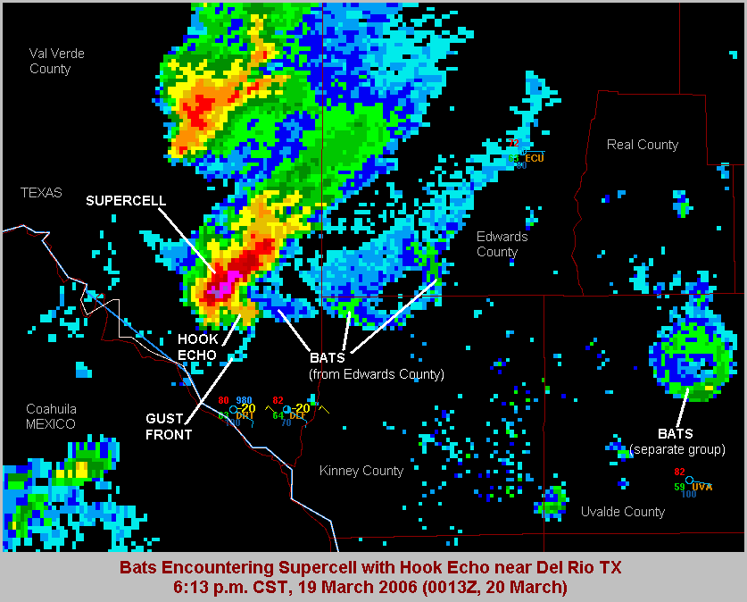 |
| Figure 9: Biological targets, such as birds, insects and bats, also show up on radar. This has long been an issue in southwest Texas where large populations of bats emerge each night. |
No comments:
Post a Comment