2013/04/30

101: Clouds III


In 101: Clouds II, I covered the low etage of clouds, consisting of five genera. In this post I’ll cover the middle and high etages, beginning with the former. The two genera of middle clouds have bases around 2-7km; it is at these altitudes where clouds regularly consist of a mix of water droplets, ice crystals, and super-cooled water droplets. Super-cooled water is water that is below freezing temperature, but remains a liquid until either the temperature cools even more, or particles in the air (such as other ice crystals) come in contact with the droplets, causing them to instantly freeze. An example of this state of water can be seen with a simple experiment: place a few small, equally sized drops of water on a smooth, clean metal surface, such as the underside of a soup can, and then put it in the freezer. Check on the drops every few minutes until they begin to freeze. More than likely, there will be a time when some of the drops have frozen while the others remain liquid. Since the metal surface conducts heat well, you can be sure that all the drops are at essentially the same temperature, thus the drops that are still liquid must be below freezing, and therefore they are super-cooled drops. Since a small change in temperature or the presence of ice forming particles can cause super-cooled droplets to become regular liquid water or ice crystals, respectively, clouds that consist of these drops are often in a constant state of change.


Altocumulus (Ac)
Altocumulus
Altocumulus
Altocumulus stratiformis
Altocumulus castellanus
Altocumulus stratiformis
Altocumulus as it appears on visible imagery
Altocumulus as it appears on infrared imagery
These cumuliform clouds often resemble stratocumulus clouds, only noticeably higher. Weak convection in a mid-level layer of moisture is often the cause of these clouds, thus they typically do not show much vertical extent, except in the case of the Altocumulus castellanus. In the case of Altocumulus stratiformis, the individual cloud elements are often very flat and without much space between them; this is sometimes referred to as “mackerel sky”. On satellite imagery, altocumulus appears similar to stratocumulus, except a little brighter on infrared images, since they are cooler.


Altostratus (As)
Altostratus with small cumulus closer to the ground

Altostratus
Altostratus undulatus
Altostratus translucidus
Altostratus (As) as it appears on visible imagery
Altostratus (As) as it appears on infrared imagery
This genus of stratiform cloud regularly occurs ahead of an approaching warm front. They will likely be preceded by cirrostratus and followed by stratus or nimbostratus. While they rarely produce precipitation that reaches the surface, the undersides of these clouds will often exhibit streaks of precipitation that evaporates before reaching the surface, called virga. If the layer the virga are evaporating into becomes saturated, a cloud may form, effectively lowering the cloud base. If this continues, precipitation from the descending cloud will reach the ground, marking the transition from altostratus to nimbostratus. Altostratus differs from its lower counterparts in that the sun is usually very apparent, especially in the case of Altostratus translucidus. While often very featureless, the Altostratus undulatus species often displays a wavy underside much like Stratus undulatus. In both visible and infrared satellite images, altostratus appears very similar to nimbostratus.


High Clouds
The final etage is the high clouds. These clouds have bases at about 5-13km, although in the tropics they may have bases as high as 18km. At this height, clouds consist almost entirely of ice crystals. While these clouds often precede weather systems, they themselves never produce precipitation that reaches the ground, although virga consisting of ice crystals are quite common.


Cirrus (Ci)
Cirrus
Cirrus
Cirrus castellanus
Cirrus
Cirrus fibratus
Cirrus floccus
Cirrus vertebratus
Cirrus fibratus
Cirrus as it appears on visible imagery
 
Cirrus as it appears on infrared imagery
Cirrus are the quintessential ice cloud. There are many different species of this genus, but all are composed of wisps of white cloud, hence the name “cirrus”, which comes from the Latin term for lock or curl of hair. These clouds are often composed of two parts: a dense cloudlet and a long streak of ice crystals being blown downwind. When there are relatively few streaks the cloud is of the Cirrus floccus species, when the opposite is true and the source cloudlets are absent the cloud is of the Cirrus fibratus species. In the case of the Cirrus castellanus species a small amount of vertical growth in the form of small turrets will appear along the top of the cloud. Finally, the strangest species is Cirrus vertebratus, which appears to have fall streaks extending in opposite directions forming what vaguely resembles a rib cage, which is where the name “vertebratus” comes from. The tops of tall cumulonimbus will consist of thick cirrus clouds that may drastically outlive the parent 
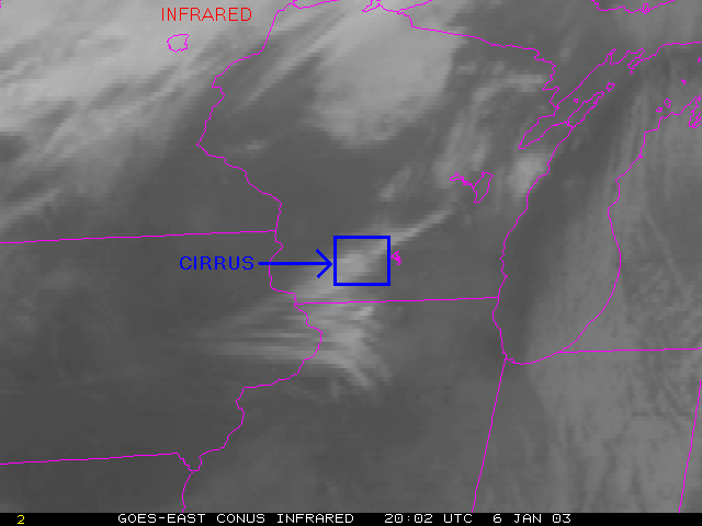
cumulonimbus cloud. Cirrus appears on visible satellite images as streaks of white cloud that may cast noticeable shadows on lower clouds and may seem somewhat transparent. On infrared images, cirrus will appear as wisps of bright white to medium grey, depending on the density of the clouds.


Cirrocumulus (Cc)
Cirrocumulus stratiformis
Cirrocumulus that appears to be transitioning into cirrus or cirrostratus
Cirrocumulus undulatus
Cirrocumulus lacunosus
Cirrocumulus undulatus
Cirrocumulus as it appears on visible imagery

This is an infrared image at the same time as the visible picture above
This high cloud is the only genus in this etage to contain a small amount of super-cooled water droplets. As with the super-cooled water in the middle clouds, any particles in the air will cause the water to instantly freeze, at which point the cloud will consist of only ice and will have essentially become a cirrus cloud. It is for this reason that cirrocumulus clouds are the rarest of the ten official cloud genera, since they are likely in the process of becoming a cirrus or cirrostratus cloud. Sometimes this genus will appear in extensive sheets of more-or-less uniform cloud elements; this is the Cirrocumulus stratiformis species. Another species, Cirrocumulus undulatus, will exhibit some wave-like patterns, in much the same manner as the undulatus species of lower cloud genera. This genus of clouds appears as a rough patch of clouds, possibly casting a shadow on clouds below, on visible satellite images and as a white to light grey patch on infrared images. In general however, cirrocumulus can often be hard to distinguish from other genera on satellite.


Cirrostratus (Cs)
Incredibly thin cirrostratus
Thin cirrostratus with halo
Unusually thick layer of cirrostratus
Cirrostratus showing some detail
Cirrostratus undulatus
Cirrostratus nebulosus with halo
Cirrostratus as it appears on visible imagery
Cirrostratus as it appears on infrared imagery
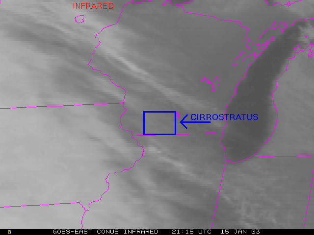
The last of the ten genera of clouds is cirrostratus. This genus often consists of an incredibly extensive layer of very thin cloud. It can be so thin, as is often the case with Cirrostratus nebulosus, that it can go unnoticed by observers on the ground. Because of their transparency, these clouds often produce vivid optical phenomena, such as halos, which are rings around the sun that might exhibit bright colors. In some cases, this genus can display some variety, such as in Cirrostratus undulatus, which appears to have ripples. Features in cirrostratus likely signifies that the cloud began as cirrocumulus that has since completely frozen. Due to the typical uniformity and thinness of this genus, they may be hard to spot on visible images and can often appear as the same shade as low layer clouds on infrared satellite imagery.

2013/04/21

Quiet Before the Storms


It's that time of year. Early to mid spring likely sees the lowest tropical cyclone activity all year. Each basin seems to have an excuse for their silence; it is not quite time for the northern hemisphere basins to start up and the southern basins tend to end earlier in their "autumn" than the northern basins do. Below are some of the specific reasons for the near lack of activity, basin by basin.


Indian Ocean (SInd and NInd)

Indian Ocean, the circle is usually a "hot spot" this time of year
The circled region on the image above is somewhat of a hot spot of  activity, especially later in the season. While there have been a large number of Invest areas there, very little has actually developed. In fact, the last storm in the area, category one Cyclone Victoria, lasted much shorter than was originally forecasted. The northern portion of the ocean is quiet, but that is rather typical this time of year.


South Pacific (SPac)

South Pacific, the insert is a Aqua/MODIS image of the highlighted system
There is a small circulation in this basin, circled above, that represents what is currently the most likely system to develop, and that is not saying much. The rest of South Pacific is rapidly becoming unfavorable for tropical cyclone development as the mid-latitude cyclone tracks begin to move closer to the equator with the approach of the austral winter. Even the passage of one of these storms' fronts will tear a tropical cyclone to pieces.


North Atlantic (NAtl)

North Atlantic; currently a very hostile region for tropical cyclones
This basin officially begins its season June,1. However, the first named storms here often occur significantly later. Right now, a handful of non-tropical weather systems occupy the basin, so the development of any tropical system is almost impossible.


Northeast Pacific (NEPac)

Northeast Pacific; water vapor image with 500mb heights and wind barbs
May, 15 is the official start of this basin's season and it is often sees its first named storm not long after that. Currently, any possibility of development is being hindered by a large and stubborn upper-level feature called an omega block, named after the Greek letter the height contours somewhat resemble. In this case, the block means a strong upper-level high pressure center is anchored right over the basin, which seriously inhibits the growth of tropical cyclones. In the above image, the colored lines are the 500mb height contours, with red being the highest, the wind barbs show the direction and intensity of the wind, also at the 500mb level, and the satellite image shows the water vapor at the same time as the overlays. Notice the dark zone right in the middle of the omega block, this signifies very dry air, which is also a hindrance to storm development. 


Northwest Pacific (NWPac)

Northwest Pacific; a cold front is making its way into the tropics
Technically this basin has begun its season with Sonamu and Shanshan. However, it has been quiet for awhile. One factor that has prevented storm development are the frontal zones associated with powerful mid-latitude cyclones further north that plow through the tropics. As with the storms in the South Pacific, a single frontal passage will wipe out almost any developing system. During the height of the season a strong subtropical high pressure ridge sets up between the tropics and the mid-latitudes, effectively protecting the developing storms. Some signs of a persistent ridge have occurred recently, but for the meantime, another front is poised to pass through the region (labeled on the above image) and disrupt any development for a little while.

2013/04/17

101: Clouds II


The first cloud etage are the low clouds. These genera have bases below 2km or so, but are not in direct contact with the ground. Some of these clouds cover a great vertical extent, even reaching into the lowest part of the Stratosphere. It is because of this variable growth that the etage is defined by the cloud base, not their tops.
 
 
Cumulus (Cu)
Fair weather Cumulus humilis
Developing Cumulus mediocris and maybe some congestus in the background
Visible satellite image of cumulus
Infrared satellite image of cumulus
These cumuliform clouds are the quintessential fair weather clouds and likely the most iconic of the genera. There are three distinct species of cumulus based on their degree of development. Cumulus humilis are small clouds that often occur on otherwise clear days. Cumulus mediocris clouds have clearly developed some and often are seen on days with a large number of convective clouds, including thunderstorms. The largest are Cumulus congestus, often referred to as towering cumulus. These are typically significantly taller than they are wide and may appear to consist of several convective towers. Occasionally these will produce light showers, but more importantly, should they continue to develop they will become an entirely different genus: cumulonimbus. Due to consisting of individual pockets of rising air, individual cloud elements are often hard to discern on satellite imagery. When they do show up, they typically appear very bright on visible images, but on infrared images their brightness will depend on the height of the cloud tops, with tall cumulus congestus appearing the brightest.


Stratus (St)
Stratus clouds
Thick stratus layer species called Stratus opacus
An extreme case of Stratus undulatus
Visible satellite image of stratus
Infrared satellite image of stratus
If cumulus are the classic fair weather cumuliform clouds, then stratus is the epitomic dreary day stratiform cloud. These low clouds often cover large areas and sometimes appear nearly featureless, as is the case with Stratus nebulosus. At other times, weak atmospheric waves will cause wave-like features in the cloud base; such is the case with Stratus undulatus. Generally stratus layers are thin enough to allow the sun or moon to shine through and they rarely produce any type of precipitation. Stratus appears on visible satellite images as a smooth layer of cloud that often can be clearly seen appearing to conform to terrain. Since stratus is such a low cloud, its top will not be significantly cooler than the ground, making it very hard to distinguish on infrared imagery.


Stratocumulus (Sc)
Stratocumulus
Stratocumulus
Stratocumulus undulatus
Stratocumulus
MODIS image featuring stratocumulus along the coast
Infrared satellite image of stratocumulus (the dark grey cloud layer along the coast)
This genus is essentially a cross of the first two genera. Stratocumulus cloud layers are often formed when very weak convection has occurred in or under a stratus layer and caused it to bunch up some into obvious individual cloud elements. These are the most common genus of cloud on Earth, especially over the ocean. One reason for this is the tendency for the ocean to be warmer than the air, particularly during the winter; this causes weak convection into an often pre-existing stratus layer. In general, the presence of stratocumulus indicates a stable air mass. Thus, when these clouds are seen feeding into a tropical cyclone, it is likely that the storm has moved into a highly unfavorable air mass and will likely be deteriorating. Since there is only a small amount of separation between the cloud elements, stratocumulus will often appear very similar to stratus on visible satellite images except under very high resolution. Like stratus, stratocumulus is often hard to detect on infrared images since they are so low.


Nimbostratus (Ns)
Nimbostratus
Nimbostratus, note the water on the roof
Nimbostratus showing some detail on its underside
Nimbostratus in satellite images

Nimbostratus are the producers of long episodes of light to moderate precipitation. From the ground they appear very similar to stratus, except often even more uniform and generally much thicker, such that the sun or moon usually cannot be seen. This genus is sometimes classified under middle clouds or a category for clouds of great vertical extent. This is probably because they often will initially form from middle clouds and then extend downward as they begin to precipitate. Nimbostratus will often appear similar to stratus on visible imagery, but on infrared images they will be significantly brighter due to their much higher cloud tops.


Cumulonimbus (Cb)
Large cumulonimbus with its characteristic anvil shape
Tornado extending from the mesocyclone at the base of a super cell cumulonimbus
Wall cloud extending from the mesocyclone at the base of a super cell cumulonimbus
Visible satellite image of cumulonimbus
Infrared satellite image of cumulonimbus
Visible satellite image of cumulonimbus super cells
Infrared satellite image of a group of cumulonimbus (center)
These are the big weather makers. Cumulonimbus form from cumulus clouds that have grown considerably in vertical extent. Clouds of this genus produce heavy showers and occasionally severe weather. The backbones of these clouds are the robust updrafts caused by the rapidly rising air. These updrafts will continue upward until the air ceases to be buoyant, such when the air encounters an inversion layer, such as the tropopause: the permanent inversion at the base of the stratosphere. At this point the cloud will spread out horizontally creating an “anvil” shape. In some cases, the main updraft of the cloud will extend a little ways into the stratosphere purely due to its upward momentum, creating what are called “overshooting tops”. What goes up must come down, and the air that has reached its limit at the end of the updraft will have had much of its water vapor condensed, which falls as precipitation. The spent air will begin descending, creating a downdraft. This downward flow of air will occupy the same space as the updraft and begin to weaken it. Eventually the updraft will collapse altogether, causing the cloud to “rain itself out” and dissipate. If the cloud grows tall enough, the upper portion of it will consist of ice crystals, at which point the cloud is referred to as “glaciated”. Under the right conditions, some rotation will become associated with the updraft, called a mesocyclone, and in the process, separate the updraft from the downdraft. At this point the cloud is referred to as a “super cell” storm. These systems last much longer than the average cumulonimbus because the up and downdrafts don’t compete with each other, preventing the updraft from rapidly collapsing. Super cell storms are the most dangerous type of cloud, since they often spawn strong tornadoes, heavy rain, frequent lightning, and large hail. A full discussion of these clouds would take one or two full posts to cover so I’ll leave it here since this post is specifically about the types of clouds. On satellite images individual clouds can often be discerned due to their size. In visible imagery cumulonimbus appear very bright, especially if they are glaciated. At high enough resolution, the overshooting tops will be visible as small bumps on the top of the cloud. These clouds are also easily identified on infrared images due to the very cold temperature of their tops.